Project description
FUSION aims to improve coordination, balance and sustainable water management in the cross-border Lys river catchment.
In France, the Lys flows through rolling landscapes, which leads to flows at a fairly high speed. On the other side of the border, its tributaries cross wide plains, which slow down flows and lead to frequent flooding. This natural phenomenon is aggravated by human activity: urbanisation, soil sealing, the disappearance of wetlands, etc. A change in climate has also been observed: periods that are sometimes drier and sometimes wetter.
The partnership between USAN, SYMSAGEL, SERTIT, PFO and HIT carried out under FUSION consists in slowing down water flows and promoting better biodiversity on both sides of the border.
Natural hydraulic infrastructure will be accompanied by eco-responsible measures in response to climate change. All these measures will contribute to their integration into the landscape, to storing water, preventing soil erosion and providing a stable environment for biodiversity, as well as for the economic (agricultural) and recreational dimension.
FUSION will also make it possible to implement innovative tools in this cross-border area, through cross-border satellite-image mapping of vulnerability in flood-prone areas and of the impact of past and future flooding events in the Lys river catchment.
Project objectives
The partnership aims to :
– Reduce the risk of flooding in urban and agricultural areas.
– Develop cross-border communication on coordinated water management for flooding, through cooperative action between the partners.
– Raise awareness among residents about methods of managing flood risks and their environmental added value.
– Develop awareness of flood risk among local stakeholders and residents.
– Contribute to improving biodiversity.
– Better manage developments in order to recreate more biodiversity and make it more resilient to climate change.
Project communication
Innovative communication solutions to support change.
In order to prepare our cross-border territories to be resilient in the face of the consequences of climate change, it is necessary to raise awareness among residents and stakeholders about the risks.
The project plans to create an innovative cross-border communication tool based on awareness-raising about floods. Indeed, floods never stop at a border.
The aim of the project is to produce, transfer and pass on information on data relating to flooded areas thanks to cross-border satellite images.

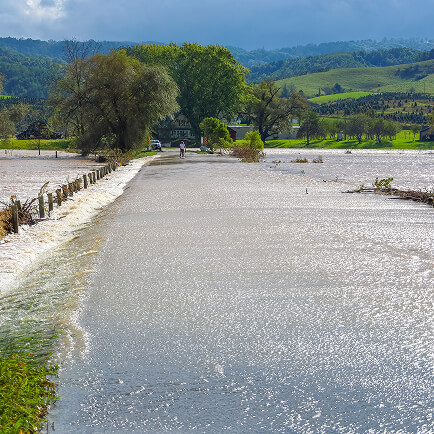
Flooding in the Lys river catchment
The natural configuration of the Lys river catchment has been generating flooding in agricultural and urban areas for more than 25 years, causing major damage to the population, agriculture and the environment: in 2001, 2002, 2005, 2007, 2009, 2012, 2014, 2016, 2019, 2021.
Over this period, statistics show an increase in the frequency of floods as well as greater intensity. Although flooding is a natural phenomenon, its magnitude is the result of several factors, including the influence of climate change, soil sealing, the artificialisation of watercourses and the disappearance of wetlands. Urbanisation in cross-border territories, sometimes even in flood-prone areas, changes in land use due to the development of intensive agricultural practices, and the historical culverting of watercourses have made municipalities increasingly vulnerable to flood risk.
The rainfall regime is changing, leading to wetter winters, more rainy days and drier summers, but with more frequent and more intense summer storms. In winter, this will result in more frequent and more significant river overflows. In summer, it is mainly runoff phenomena that will worsen.
It is therefore becoming urgent to work both on slowing down water flow and on its storage. This is why each partner will work on slowing water flow on tributaries of the Lys and will thus have a collective impact on cross-border flood peaks. The aim is to slow the speed of the water in order to better protect against flooding in urbanised areas, by combining the development of light natural features (ponds, water bodies, fascines, meanders, hedges and planting of woody species of regional origin, etc.) and water retention structures.
These infrastructures will also help to reduce diffuse pollution, improve the quality of surface water and promote summer water and drought management.
Preventing further destructive flooding requires giving rivers back space and freedom to move wherever possible, while of course minimising the impact on the population and reconnecting areas to the river with a view to recreating its ecological resilience, such as bringing culverted watercourses back to the surface in their valley bottoms. Bringing watercourses back to the surface is generally accompanied by lateral and sometimes vertical decompartmentalisation of the watercourse.